

Pana (Mont Seuc >> Ortisei)
Discesa dalla stazione a Monte fino a Ortisei
Downhill from the top station to Ortisei
Abstieg von der Bergstation nach St. Ulrich
Waypoints
Lunghezza - Length - Länge
Tempo - Time - Dauer
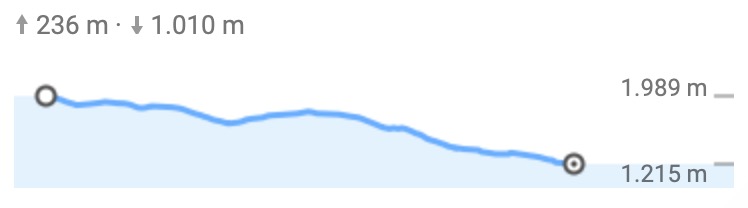
Dislivello salita - Difference in height uphill - Höhenunterschied bergauf
Dislivello discesa - Difference in height downhill - Höhenunterschied bergab
Difficoltà - Difficulty - Schwierigkeit
Downhill from the top station to Ortisei
Abstieg von der Bergstation nach St. Ulrich

Waypoints
- Stazione a monte - Top Station - Bergstation
- Malga Schgaguler Schwaige - Zoo
- Panchina gigante - Ikaro
- Rauchhütte
- Saltria
- Pana
- St. Christina
- Hotel Diamant
- Skasa
- Ortisei
- Stazione a valle - Valley Station - Talstation
Lunghezza - Length - Länge
- 20,1 km
Tempo - Time - Dauer
- 2h Bike
- 4h 35 m Walking
Dislivello salita - Difference in height uphill - Höhenunterschied bergauf
- 236 m
Dislivello discesa - Difference in height downhill - Höhenunterschied bergab
- 1010 m
Difficoltà - Difficulty - Schwierigkeit
- MEDIUM
- Open Google Maps PANA1 PANA2
- Download KML
- Download GPX